
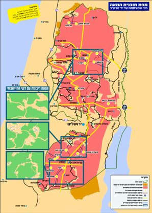
The Yesha Council has published US President Donald Trump’s annexation map to show how a road system could eliminate the danger of enclave settlements and prevent both a building freeze and the ultimate demolition of at least 15 settlements.
It’s part of their two-part campaign against Trump’s plan.First and foremost, leading members of the Yesha Council want to ensure that a Palestinian state is not created. After that, they are at odds over Trump’s annexation map that allows Israel to apply sovereignty to all the West Bank settlements, including the Jordan Valley and the Dead Sea.
They have argued that they want sovereignty, but not based on Trump’s map, which they argued weakens the settlements.
The map as it is currently written gives Israel territorial contiguity in the Jordan Valley and places the Palestinians there, including those in the city of Jericho, into enclaves, with little territorial continuity.
But in the West Bank the map favors Palestinian contiguity and places Israeli settlements into enclaves.
Based on their reading of the map, settlers argue that roads that run through the West Bank would not be fully accessible to Israelis in the settlements. So, for example, settlers in the South Hebron Hills would no longer be able to drive straight to Jerusalem and would instead be offered only one option, a road through Beersheba.The same would be true for the Kiryat Arba settlement and the Jewish community in Hebron, where the Tomb of the Patriarchs is located.
Residents of Efrat, for example, could easily access Jerusalem, but would have to drive to Beersheba and then back to Hebron, if they wanted to go to the Tomb of the Patriarchs. Settlers would have travel options only to the nearest points on the Green Line to their home communities but would no longer be able to crisscross the West Bank.
Large settlements with easy access to central areas of Israel, would not necessarily feel the impact of the map. Settlements in more isolated locations would be connected to each other, but would link to remote areas of the country. After that, there are 15 settlements with no connection to any other settlement \, save for a one road option to a Green Line within sovereign Israel.
So for example, residents of Elon Moreh, who can now travel in the direction of the Jordan Valley, Jerusalem and Tel Aviv, would only be able to head to the Jordan Valley.
Prime Minister Benjamin Netanyahu has said that the final map would provide territorial contiguity through roads, but neither he nor the settlers have published such a map. In the interim the settlers have published road alternatives for Gush Etzion, the South Hebron Hills and enclaves settlements in the Samaria region.
Their map places those areas in green and white boxes, next to the duplicate areas on the map.