Water Hikes involve walking long stretches inside the stream-bed either wading or swimming.
By EREZ SPEISERMajrase in the Betiha Valley(photo credit: Wikimedia Commons)
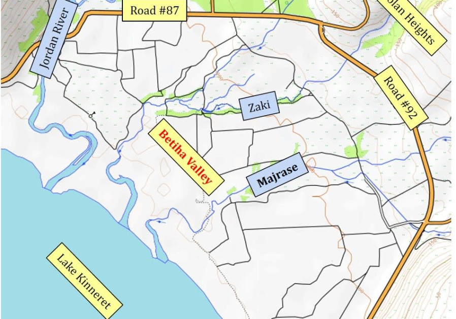
The summer is knocking on our doors, and it is the perfect time to enjoy a "water hike."Water Hikes involve walking long stretches inside the stream-bed either wading or swimming. It is great fun and probably the only way to enjoy a hike during the "boiling" Israeli summer.The Betiha Valley lies on the North Eastern shore of lake Kinneret, at the foot of the Golan Heights. It is a meeting point of the 4 major streams of the Central Golan (Zavitan, Meshushim, Yahudiaya & Daliyot) on their way to the Sea of Galilee. Here the rivers form a delta of small streams and lagoons. The scenery and atmosphere in the area is unique. You cannot find anything that resembles it elsewhere in Israel.The whole area is a protected natural reserve. However, there are two sections that are authorized for Hiking. The Zaki steam & the Majrase stream.The Zaki Stream:The Zaki is the more adventurous of the two. It is longer, and in some places, there are long lagoons that are 2 meters deep and require swimming. It is not regulated which has is pros and cons.It is more interesting, there is no entrance fee and it is less crowded compared to the Majrase. On the other hand there are no facilities such as a cafeteria, toilets, etc...Track description: Car Park GPS coordinates: 32.893762, 35.648583 Total walking Distance: 4 Km (1.5 Km of wading/Swimming)From the car park continue north for a few minutes until you reach the stream which is marked with Green markers.Follow the stream-bed for about 1.5 Km until your way will be clearly blocked with a rope and sings indicating you reached the end of the wet section. Climb to the south bank and walk about 2 km back on the dirt track parallel to the stream.Go to "Israel By Foot" Website for a full and detailed description of the hike.Majrase:The Majarse is the easier of the two hikes and is suitable also for small children that cannot swim. It is inside the payed area of the Natural Reserve and therefore has all the facilities that comes with it. On the other hand, it is less adventurous and more crowded when compared to the Zaki.Track Description: Car Park GPS coordinates: 32.885646, 35.641465Total walking Distance: 1.5 Km (600 m of wading).From the park entrance walk north for a few minutes until you reach the stream. Follow the stream-bed for about 600 m until your way will be clearly blocked with sings indicating you reached the end of the wet section. Climb to the south bank and walk back about 1 Km to the park entrance.More details at https://en.parks.org.il/parksandreserves/majrase/Pages/default.aspxHikes courtesy of Israel by Foot - Hiking the Holy Land.
The Environment and Climate Change portal is produced in cooperation with the Goldman Sonnenfeldt School of Sustainability and Climate Change at Ben-Gurion University of the Negev. The Jerusalem Post maintains all editorial decisions related to the content.