In terms of the values of the socioeconomic index, the east Jerusalem neighborhoods are similar to the distinctive haredi neighborhoods in Jerusalem.
By DAFNA SHEMER(photo credit: JERUSALEM INSTITUTE FOR POLICY RESEARCH)
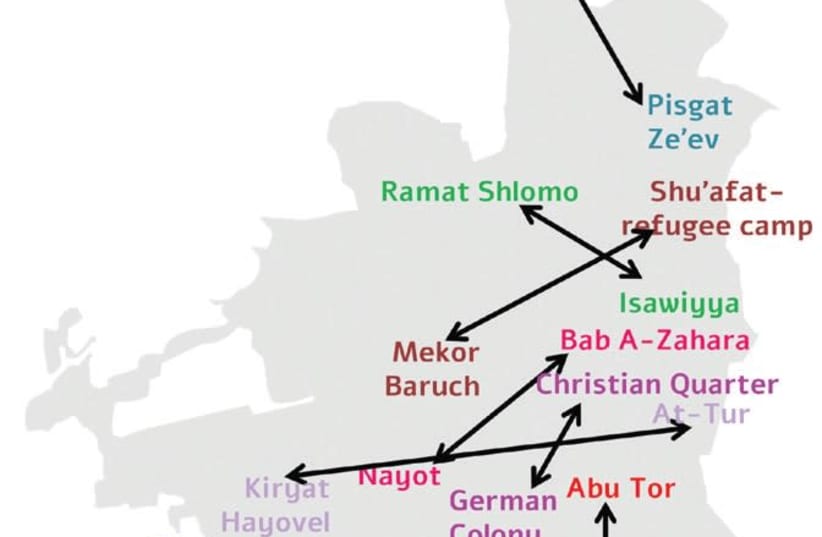
When we think of east Jerusalem, we tend to perceive it as a single geographic unit, when in fact east Jerusalem, like west Jerusalem, is constructed of neighborhood after neighborhood, each of which is completely different from the others. The Arab neighborhoods of east Jerusalem are home to approximately 330,000 residents – the population of a major city in Israel.Jerusalem is most familiar to us from its west side, with its diverse neighborhoods. In order to become a little better acquainted with east Jerusalem, we turned to the socioeconomic index published by the Central Bureau of Statistics, so as to create a parallel between the neighborhoods in east Jerusalem and Jerusalem’s Jewish neighborhoods.The socioeconomic index, based on the 2008 census, included data for the different neighborhoods.To characterize the neighborhoods in east Jerusalem, we rated the Jewish and Arab statistical areas (sub-neighborhood units) in the city separately. Two rankings were created, one for west Jerusalem and one for east Jerusalem, and within each the neighborhoods were rated from a high socioeconomic level to a low socioeconomic level.Next we searched for the matching levels between west and east. Thus, for example, the Jewish neighborhood of Nayot has the highest rating among the neighborhoods in the west of the city, and the neighborhood of Bab e-Zahara (adjacent to the Old City near Damascus Gate and the Rockefeller Museum) is its parallel neighborhood. It should be remembered that this measure is relative, and in the context of the national socioeconomic index, Nayot is in cluster 19 (with 20 being the highest) while Bab e-Zahara is in cluster 5.The Armenian Quarter in the Old City and the Katamon neighborhood in west Jerusalem also have the same rating in their separate rankings. It is noteworthy that Katamon contained a majority of Christian residents before the War of Independence.The parallel data comparison leads to geographic similarities: Several of the Arab neighborhoods in the northern part of the city had a rating similar to Jewish neighborhoods in the northern part of the city. Shuafat and Pisgat Ze’ev, Dahiyat a-Salam (east of the Shu’afat refugee camp) and Neveh Ya’acov, Beit Hanina and the Ramot neighborhood. In the south as well we found “sister” neighborhoods: Arnona and Beit Safafa, and Umm Tuba and Kiryat Menahem.In terms of the values of the socioeconomic index, the east Jerusalem neighborhoods are similar to the distinctive haredi neighborhoods in Jerusalem, such as Mea She’arim, Geula and Sanhedria.As previously stated, the socioeconomic difference between the Jewish and the Arab neighborhoods is greater than the similarity between them, and they cannot be effectively compared to each other. At the same time, this type of representation helps one to associate less familiar places with those that are familiar to us.Jerusalem’s drop in its socioeconomic ranking from cluster 4 to cluster 3 provides information about the general condition of the city; but as home to 883,000 people, it is possible and indeed worthwhile to look a little deeper. For although everyone is from Jerusalem, as in most cities, the main thing is the neighborhood where you live.Translated by Gilah Kahn.
Related Tagsjerusalem neighborhoods
if(catID != 151){
var cont = `Take Israel home with the new Jerusalem Post Store